Electronic Atlas
of Georgian Glaciers
of Georgian Glaciers

Key data sources include:
During the implementation of the conducted research, a number of problems were encountered, which were successfully eliminated. In particular:
- The ASTER DEM digital terrain model, the schemes given in the catalogue and the topographic maps of the USSR of the 60s of the last century (1:50000) were used to identify the glaciers to be studied. The digital terrain model was used to perform 3D visualization of the glaciers for the purpose of terrain analysis and geographical connection of the glaciers. Using 3D visualization, the location of each glacier was specified according to the river basins ;
- A second method has also been used to confirm the accuracy of glacier identification. For all glaciers, their location coordinates were determined using GoogleEarth, which were compared with the coordinates given in the WGI (coordinates are not given in the catalogue). In the WGI, the identification code of each glacier is indicated near the reference glaciers, on the basis of which it is possible to determine their identification numbers and corresponding characteristics in the catalogue. The geographical coordinates of the studied glaciers turned out to be virtually identical to the data of the WGI, which confirmed the accuracy of the glacier identification;
- When using the SRS data, it turned out that inaccuracies were allowed when creating the catalogue, which could be overcome by comparing the contours of the glaciers of Georgia obtained from the SRS data and the contours of the glaciers depicted on the topographic maps of these years of the last century. In the last century, these topographic maps (1:50000) were not available , because they were compiled for the military and were classified. The conducted studies revealed that over the past 60 years, the area of all glaciers in Georgia has decreased. The area data for some individual glaciers given in the catalogue turned out to be less than that determined by the SRS, which is a mistake, because this indicates that the area of glaciers determined by the SRS has increased compared to the area of the same glacier determined in the 1960s. Comparison of the contours obtained from the SRS data with the contours of glaciers depicted on topographic maps of the 1960s allowed us to correct the unreliable data given in the catalogue;
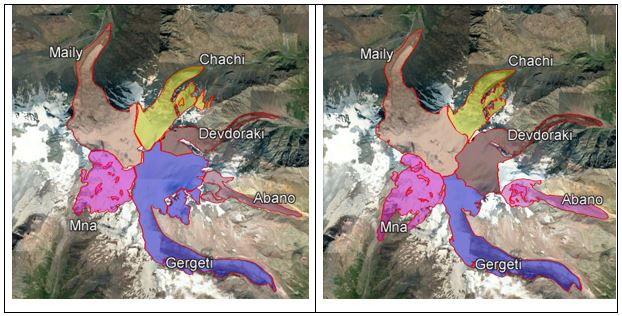
- When using open databases available worldwide, it was found that in some cases the preserved contours are inaccurate. The contours were refined by overlaying height contours created on the basis of satellite imagery and digital terrain models, and using expert knowledge. Using 3D imagery, watersheds were determined with high accuracy, which is crucial for accurate determination of glacier contours. For example, shows the contours of the Mkinvartsvery glaciers from the GLIMS database and the contours refined using the above mentioned methods. Discussion shows that the watershed contour between the Gergeti and Devdoraki glaciers has changed significantly, which has consequently cosiderably changed the contours of these glaciers, the areas they occupy, and other characteristics of these glaciers [20];
- In case of cloudiness, the use of satellite images is in most cases impossible. When observing glaciers, this limitation is added to the condition of the glacier surface itself. The glacier surface should be as free as possible from snow drifts, in particular, the SRS should be carried out from the end of ablation until the first snowfall. This period depends on the location of the glacier, altitude, climate and weather conditions. For Georgia, this time interval approximately covers the period from the end of June to the beginning of October . In cases where, due to these limitations, no acceptable SRS information was found for a given glacial basin for a given period, the available information for dates bordering the selected period is used.
- Based on the conducted studies, it was determined that the degradation of glaciers is occurring much faster in eastern Georgia than in western Georgia, which is due to the large differences in the climate of these parts of the country. In particular, the climate of eastern Georgia in the subregion where glaciers are widespread is characterized by a moderately dry climate of high mountains without a real summer. The continental climate in eastern Georgia creates smaller, thinner glaciers compared to the western part of the country, although it creates spectacular landscapes (e.g. the Tergi River glacial basin). The subregion of western Georgia, where glaciers are located, is characterized by a humid highland climate with permanent snow and glaciers. In western Georgia (Enguri, Kodori, Rioni basins), humid Atlantic air masses provide abundant precipitation, which creates larger and thicker glaciers compared to the eastern part of the country. For example, the Enguri glacial basin. Taking this into account, all the planned studies were carried out separately for the eastern and western parts of the country.
- It is important that various data quality assessment and quality control (QA/QC) procedures were used at all stages of the research, as a result of which, in many cases, the reliability of the results obtained was ensured to a high degree.